

Avulsion of the Magdalena River, Pinillos Sector, Colombia
German Vargas Cuervo
Listen to the introduction
Abstract
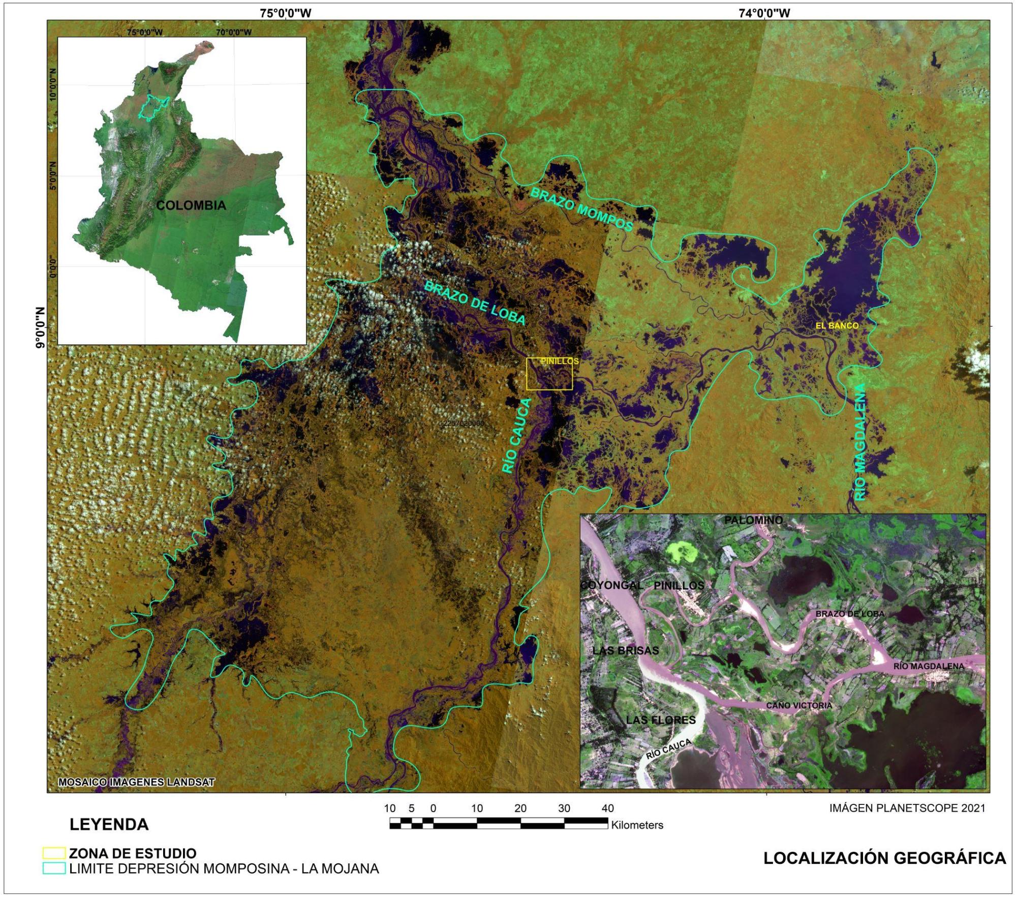
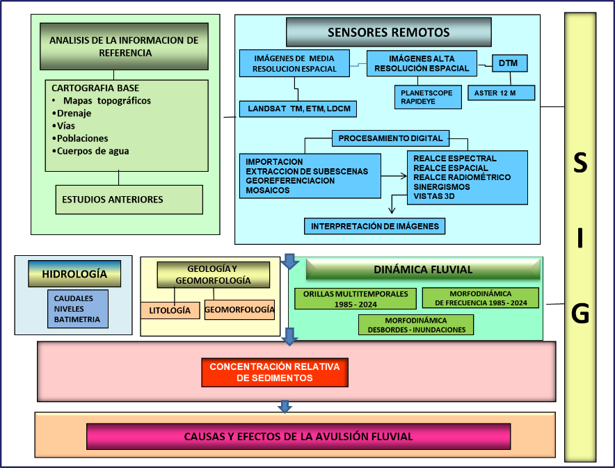
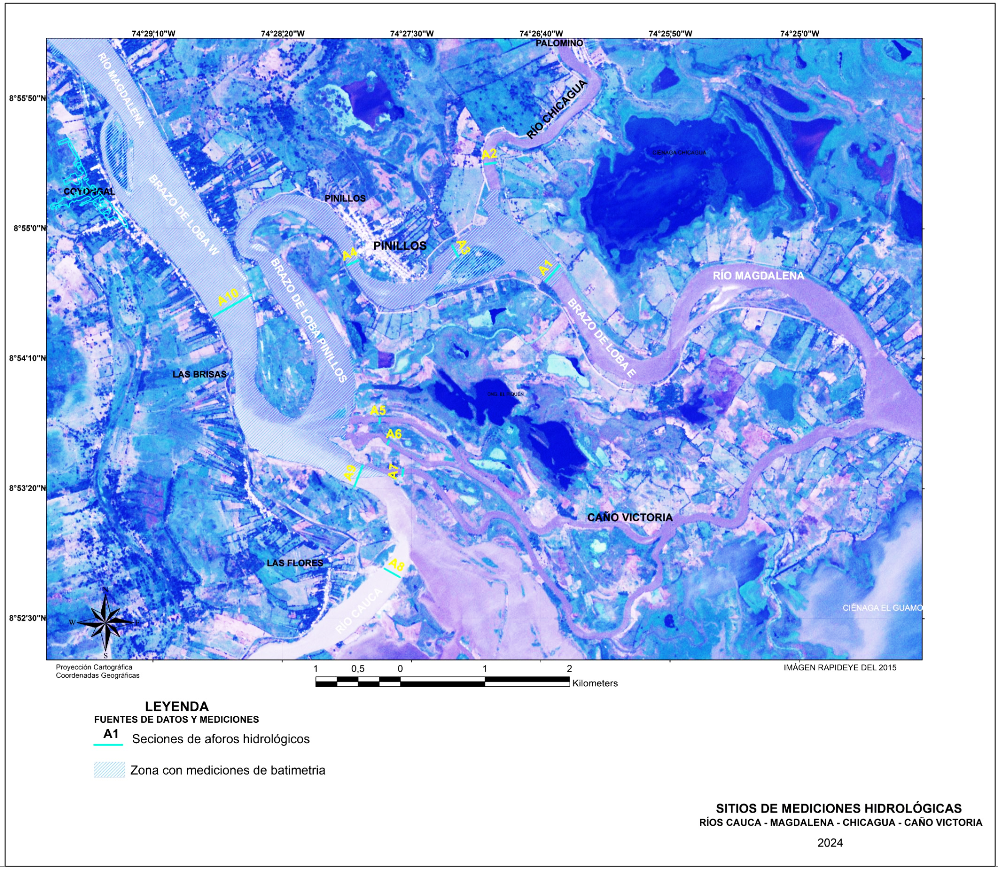
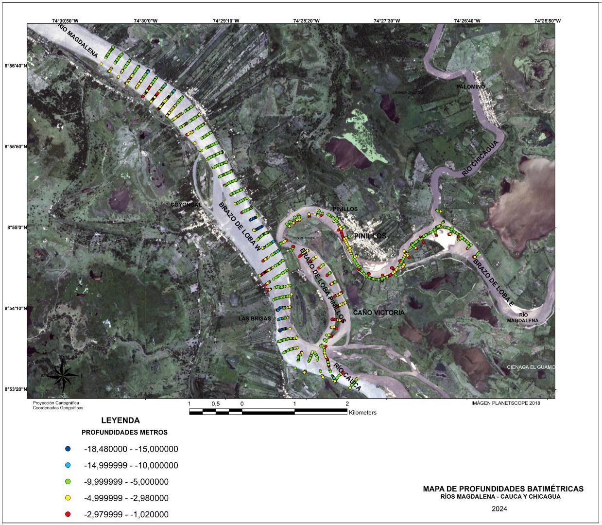
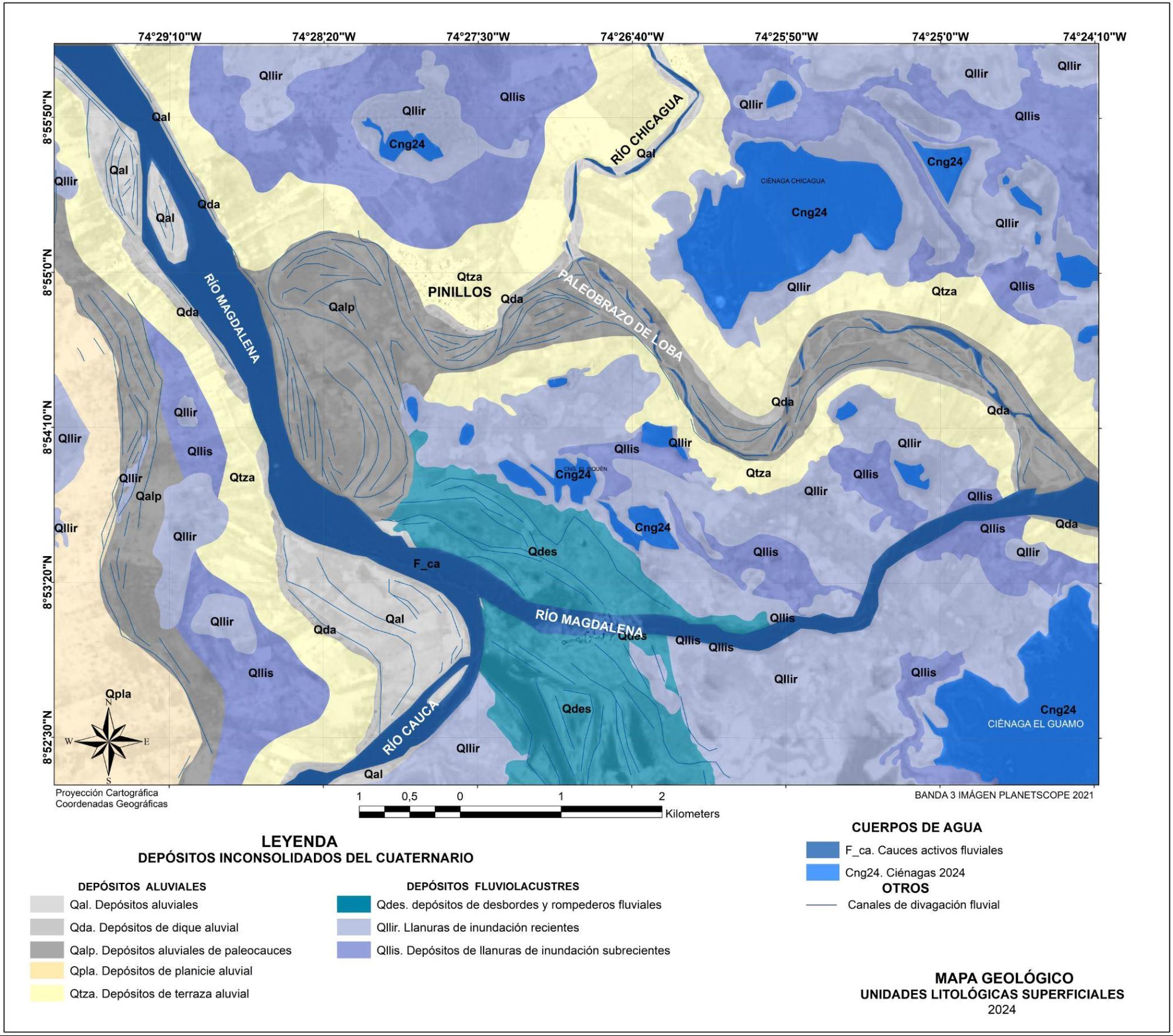
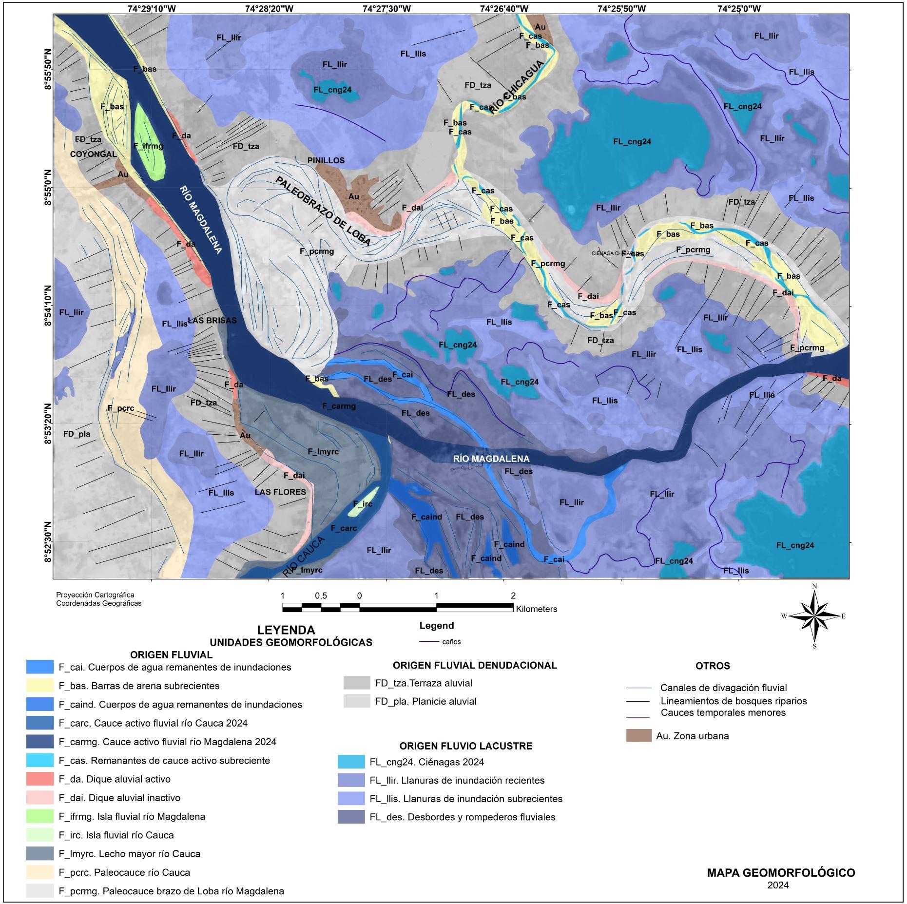
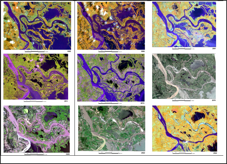
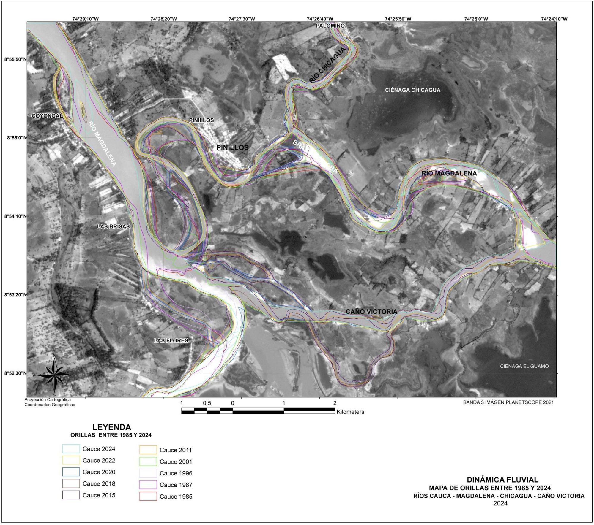
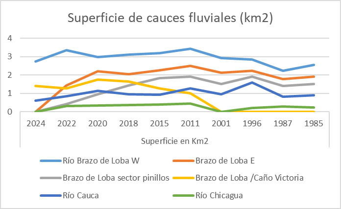
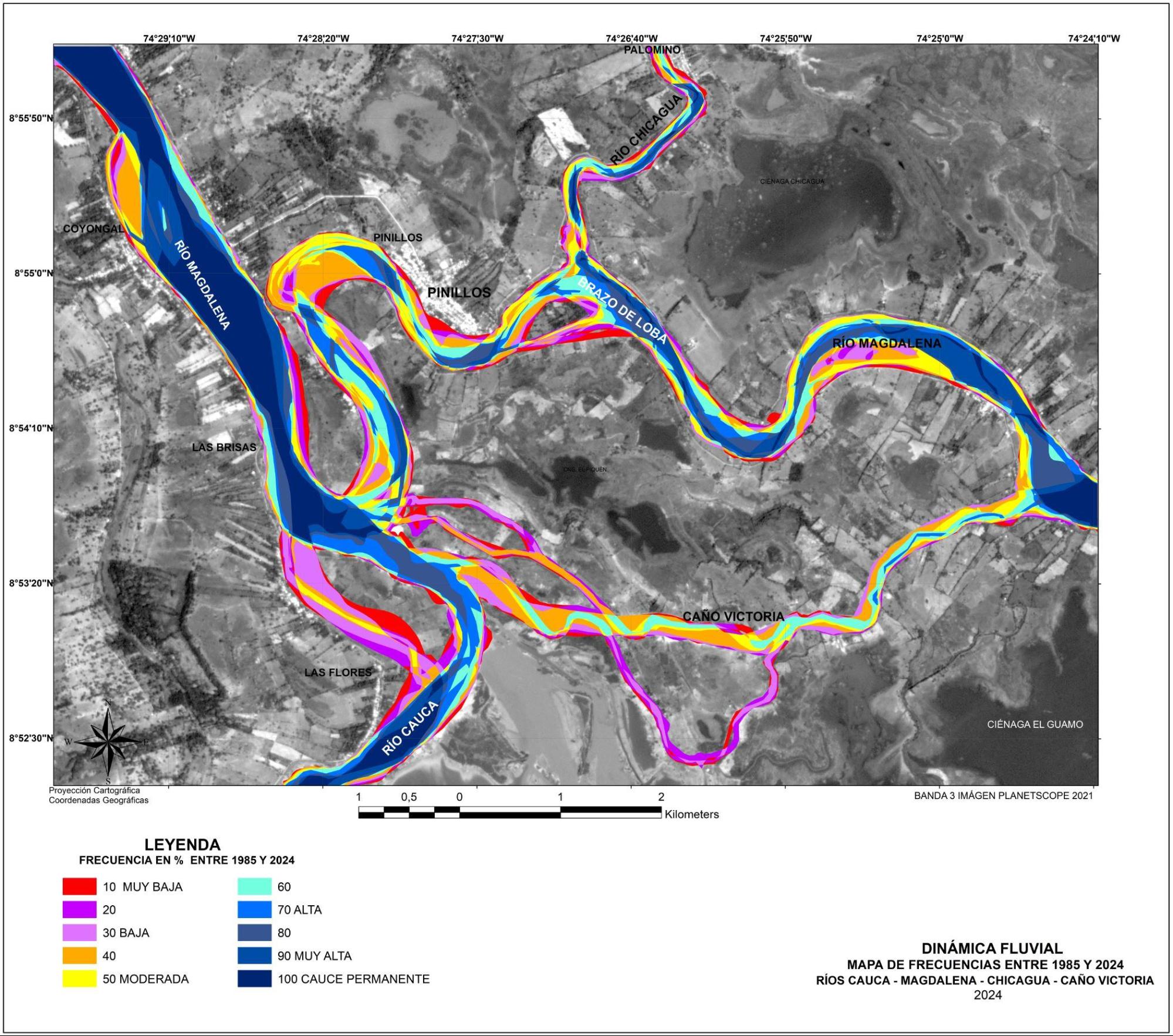
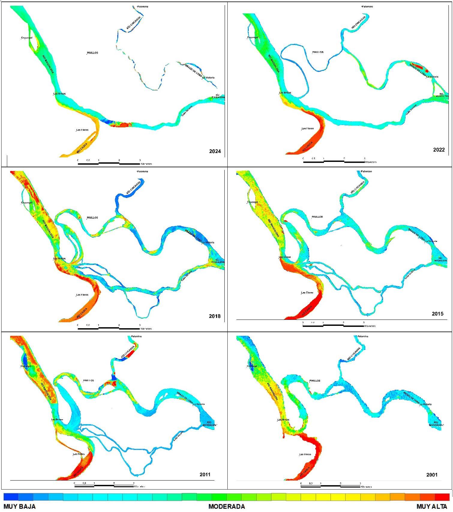
Fluvial dynamics or avulsion occur in plains, intramontane valleys, alluvial plains in low basins, river confluences, and fluvio-marine deltas, and are driven by factors such as sedimentation, hydroclimatic events, geology, geomorphology, and floods. In the Magdalena River, the main river of Colombia, a rapid morphological and hydrological change took place in its lower basin due to the closure of a section of one branch and the formation of a new channel. This altered the area’s hydrological and geomorphological configuration, contrasting with typical meandering dynamics. In this study, a multitemporal analysis (1985–2024) of satellite images was performed to assess the morphodynamic evolution of the Magdalena and Cauca Rivers. Additionally, natural factors such as geology, geomorphology, fluvial dynamics, and sediment concentration were evaluated for their role in the avulsion of the Magdalena River in the Pinillos area of Colombia. As a result, a thematic map was developed to systematically assess and monitor physical variables in fluvial avulsion studies. Contrary to the predicted scenario (the closure of the Pinillos meander), after the 2010– 2011 La Niña event the Magdalena River suddenly changed its course through a channel called Victoria, altering the geomorphological and hydrological configuration of that sector of the river. The resulting cartography shows evidence of sedimentation in the closed branch and the widening and connection of smaller channels that formed the new active bed of the Magdalena River.
 BRJ now supports Model Context Protocol
 ChatGPT
 Claude
 Gemini
Research ID
Universal Unique Research ID
Citation Generator
Cite This Research Manuscript
Cuervo, G. V. (2025). Avulsion of the Magdalena River, Pinillos Sector, Colombia. Boston Research Journal of Social Sciences & Humanities, 5(7), 13-34. https://doi.org/10.63942/brjssh.v5.i7.p13.59187
Figures



References
Alvarado, M. (2008). Río Magdalena. Navegación Marítima y fluvial (1986 – 2008). Ediciones Uninorte.
Alvarado, M. (2016). Sur del Atlántico una Nueva Oportunidad. Gobernación del Atlántico, Fundación Promigas y Fundesarrollo.
Canudas Grabolosa, P., Pascual, A. M., & Garcia-Molsosa, A. (2024). Reconstructing palaeogeography and landscapes around the ancient Greek colony of Abdera (Thrace, NE gr.): an integrated remote sensing approach. European Journal of Remote Sensing, 57(1). https://doi.org/10.1080/22797254.2024.2392753
Castro-Padilla, R. A., Jiménez-Peñaranda, C. E., Rojas-Martínez, E. E., Lascarro-Navarro, F. D., & Manco-Jaraba, D. C. (2023). Análisis multitemporal y dinámicas fluviales del brazo de Mompox (rio Magdalena), corregimiento de Cantera, Bolívar, Colombia. Ingeniería, 28(1).
Chadwick, A. J., Greenberg, E., & Ganti, V. (2023). Remote Sensing of Riverbank Migration Using Particle Image Velocimetry. Journal of Geophysical Research: Earth Surface, 128(7). https://doi.org/10.1029/2023JF007177
CIRMAC & UNINORTE. (2016). Proyecto susceptibilidad al cierre del meandro de Pinillos en el río Magdalena. [Informe técnico].
CORMAGDALENA & UNINORTE. (2003). Proyecto Sitios Problema a la Navegación Fluvial, Sector Pinillos. [Informe técnico].
Díez-Herrero, A., Mateos, R. M., Vázquez-Tarrío, D., López-Marcos, A., & Brao-González, F. J. (2024). One catastrophic flood every millennium: Synchronicity of extreme floods and global warm periods in the multi-archive record of the Roman theatre of Guadix (Granada, SE Spain). Global and Planetary Change, 233. https://doi.org/10.1016/j.gloplacha.2024.104363
Dingle, E. H., Sinclair, H. D., Venditti, J. G., Attal, M., Kinnaird, T. C., Creed, M., Quick, L., Nittrouer, J. A., & Gautam, D. (2020). Sediment dynamics across gravel-sand transitions: Implications for river stability and floodplain recycling. Geology, 48(5), 468–472. https://doi.org/10.1130/G46909.1
Gomes, M., Ralph, T. J., & Humphries, M. S. (2023). Contemporary channel adjustment and geomorphic sensitivity of the lower Mara River and its floodplain wetlands, Tanzania. Geomorphology, 425. https://doi.org/10.1016/j.geomorph.2023.108583
Graves, B. P., Ralph, T. J., & Morgan, A. M. (2025). Channel breakdown and avulsion in arroyos feeding the Little Colorado River, Arizona, USA. Geomorphology, 468. https://doi.org/10.1016/j.geomorph.2024.109501
Greenberg, E., Chadwick, A. J., & Ganti, V. (2023). A Generalized Area-Based Framework to Quantify River Mobility From Remotely Sensed Imagery. Journal of Geophysical Research: Earth Surface, 128(9). https://doi.org/10.1029/2023JF007189
IDEAM & CORMAGDALENA. (2001). Estudio ambiental de la Cuenca Magdalena – Cauca y elementos para su ordenamiento territorial. [Informe técnico].
Larue, D. K., Allen, J., Beeson, D., & Robbins, J. (2023). Fluvial reservoir architecture, directional heterogeneity and continuity, recognizing incised valley fills, and the case for nodal avulsion on a distributive fluvial system: Kern River field, California. AAPG Bulletin, 107(3), 477–513. https://doi.org/10.1306/09232220163
Lee, D. B., Martin, H. K., & Edmonds, D. A. (2022). A method to detect abrupt shifts in river channel position using a Landsat-derived water occurrence record. Earth Surface Processes and Landforms, 47(15), 3546–3557. https://doi.org/10.1002/esp.5472
Martin, H. K., & Edmonds, D. A. (2022). The push and pull of abandoned channels: how floodplain processes and healing affect avulsion dynamics and alluvial landscape evolution in foreland basins. Earth Surface Dynamics, 10(3), 555–579. https://doi.org/10.5194/esurf-10-555-2022
Mitten, A. J., Howell, L. P., Clarke, S. M., & Pringle, J. K. (2020). Controls on the deposition and preservation of architectural elements within a fluvial multi-storey sandbody. Sedimentary Geology, 401. https://doi.org/10.1016/j.sedgeo.2020.105629
Nota, P. J., Zhang, X., Liu, H., Mubikirwa, H., & Majid, A. (2024). Effects of upstream and downstream boundary conditions on lacustrine shallow-water delta morphologies: A numerical modeling approach. Marine and Petroleum Geology, 167. https://doi.org/10.1016/j.marpetgeo.2024.106966
Słowik, M., Dezső, J., Salem, A., Puhl-Rezsek, M., Gałka, M., & Kovács, J. (2024). The evolution of meandering rivers in sedimentary basins: Insights from the lower Drava (Hungary/Croatia). Earth Surface Processes and Landforms, 49(2), 642–663. https://doi.org/10.1002/esp.5726
Smith, L. C., Fayne, J. V., Wang, B., Kyzivat, E. D., Gleason, C. J., Harlan, M. E., Langhorst, T., Feng, D., Pavelsky, T. M., & Peters, D. L. (2023). Peace-Athabasca Delta water surface elevations and slopes mapped from AirSWOT Ka-band InSAR. Remote Sensing Letters, 14(12), 1238–1250. https://doi.org/10.1080/2150704X.2023.2280464
Speed, C. M., Sylvester, Z., Durkin, P. R., & Flaig, P. P. (2024). Three-dimensional anatomy of a Cretaceous river avulsion. Geology, 52(12), 885–890. https://doi.org/10.1130/G52254.1
Valenza, J. M., Edmonds, D. A., & Weissmann, G. S. (2022). Quantifying river avulsion activity from satellite remote sensing: Implications for how avulsions contribute to floodplain stratigraphy in foreland basins. Journal of Sedimentary Research, 92(6), 487–502. https://doi.org/10.2110/jsr.2021.038
van de Vijsel, R. C., Scheffer, M., & Hoitink, A. J. F. (2024). Tipping points in river deltas. Nature Reviews Earth and Environment, 5(12), 843–858. https://doi.org/10.1038/s43017-024-00610-5
van Yperen, A. E., Holbrook, J. M., Poyatos-Moré, M., & Midtkandal, I. (2024). Backwater length estimates in modern and ancient fluvio-deltaic settings: Review and proposal of standardized workflows. Earth-Science Reviews, 250. https://doi.org/10.1016/j.earscirev.2024.104692
Vargas Cuervo, G. (2003). Proyecto sitios problema a la navegación fluvial, sector Pinillos. “geología, geomorfología, zonificación de la resistencia de los materiales a la erosión fluvial dinámica fluvial, dinámica de cuerpos de agua y zonificación de la susceptibilidad a las inundaciones”. [Informe técnico].
Vargas Cuervo, G. (2016a). Determination of the Relative Sediment Concentration in Water Bodies Using Remote Sensing Methodology. Cuadernos de Geografía: Revista Colombiana de Geografía, 26(1), 11-24. https://doi.org/10.15446/rcdg.v26n1.56021
Vargas Cuervo, G. (2016b). Proyecto susceptibilidad al cierre del meandro de Pinillos en el río Magdalena. “geología, geomorfología, dinámica fluvial, dinámica de cuerpos de agua, escenario morfodinámico al cierre del meandro y alternativas de mitigación”. [Informe técnico].
Vargas Cuervo, G. (2025). Geología y geomorfología de ríos tropicales conocer los ríos previene desastres. Coedición Universidad Nacional de Colombia - IGAC.
Vargas Cuervo, G., & Alvarado Ortega, M. (2018). Los ríos Cauca y Magdalena adaptan sus cauces a los cambios naturales. Revista Ronda Sostenible, 19-21.
Xu, Z.-H., Wu, S.-H., Plink-Björklund, P., Zhang, T., Yue, D.-L., Qian, Q.-H., Li, Q., & Feng, W.-J. (2025). Autocyclic switching processes and architecture of lobes in river-dominated lacustrine deltas. Journal of Palaeogeography, 14(1), 126–140. https://doi.org/10.1016/j.jop.2024.12.004
Zhang, J., Wang, Q., Zhan, C., Li, Z., Cao, Y., Wang, H., Liu, Z., Yu, L., Song, Q., Li, Y., Su, T., Zhu, J., & Shi, H. (2024). Morphological evolution of the Qingshuigou subaqueous delta of the Yellow River before and after the operation of the Xiaolangdi Reservoir (1997-2007). Frontiers in Marine Science, 11. https://doi.org/10.3389/fmars.2024.1495403
Copyright
© 2025 Cuervo. This is an open-access article distributed under the terms of the Creative Commons Attribution License (CC BY 4.0). The use, distribution or reproduction in other forums is permitted, provided the original author(s) or licensor are credited and that the original publication in this journal is cited, in accordance with accepted academic practice. No use, distribution or reproduction is permitted which does not comply with these terms.
Journal compilation © 2026 Boston Research Journals.
*Correspondence: German Vargas Cuervo
Disclaimer
All claims expressed in this article are solely those of the authors and do not necessarily represent those of their affiliated organizations, or those of the publisher, the editors and the reviewers. Any product that may be evaluated in this article or claim that may be made by its manufacturer is not guaranteed or endorsed by the publisher.